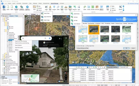
Import data
Imports spatial data, into new or existing BricsCAD drawings, as BricsCAD objects and Extended Entity Data (EED)
The power of CAD/GIS in BricsCAD
Spatial Manager for BricsCAD is a powerful BricsCAD plug-in developed for users who need to import, export, transform and manage spatial data in a simple, fast and inexpensive way

Available in English, German, Spanish, French, Russian and Portuguese
Pay once, no periodic fees

Work with XYZ files in BricsCAD
How to import shapefiles into BricsCAD
Import coordinates from Excel to BricsCAD
Import CSV into BricsCAD
Import KML to BricsCAD
Import points into BricsCAD
Ordnance Survey in BricsCAD
Visualize objects by coloring them based on their field values. Different thematic styles can be applied, using either fixed field values (categorized) or value ranges (graduated). Choose from predefined color… more
Height units remain unchanged when coordinate conversions are applied, but sometimes it is required to change them, especially when the target format is limited to a specific unit, this happens… more
Convert AutoCAD Map object data to Extended Entity Data (EDD) and store as Spatial Manager native tables. Then work directly with them or export to multiple common GIS formats for… more
Perform calculations on new or existing field values by applying a wide range of operators and functions, such as arithmetic operations (addition, subtraction, multiplication, division), mathematical functions (square root, logarithms,… more
I’m really happy with Spatial Manager. Keep up the good work!
Tom Vervaeck
Essenga
Spatial Manager is the best tool (the most intuitive, powerful, useful, rapid and good looking) I have seen up now
Valentin Dedu
Geo Log Data
Awesome solution, you are the greatest!
Peter Scigalla
IBB INGENIEURBÜRO B A T T E F E L D
Your support is well beyond excellent. I really appreciate it
Reuven Hayim
MATAL – Advanced computerized solutions
I’m a fan of your product. You have identified a gap in the CAD toolset, especially surrounding aerial imagery connectivity and exporting
Jay Curebanas
Design Technologist
I’m geophysicist and working with your solution saves me from big headaches and waste of time
Valentin Dedu
Geo Log Data
You guys put out a really great product! It have been very helpful with many of our projects
Lee Barras
DOF – Dalton, Olmsted & Fuglevand
It works with many formats of geospatial data, including multiple coordinate transformation options. Intuitive and fully integrated with CAD products. Definitely worth the money
Edvin Dan
Keep up the good work, one of the best add-on applications for CAD products in my opinion
Mark Mathews
Eagon & Associates, Inc.
Thanks for continuing to improve a great product.As a former AutoCAD Map and ArcGIS customer, I am very pleased with Spatial Manager for CAD products
Ben Hay Hammet
Ecoast LLC
I purchased two one year student licenses back in september and I am really happy with Spatial Manager, it’s a great program
Saioa Patiño
Universidad de Los Andes
I’m impressed with the new metadata editing tools!
Bill Cawley
LOTT Clean Water Alliance
First off, I’d like to compliment you for this piece of software. I’m an ArcGIS user, but the quality and usability of Spatial Manager are great! Especially the OSM-import feature is amazing!
Carel Fransen
Studio Carel Fransen
Thank you! Love the program it does exactly what I need it to do
Mark Mathews
Eagon & Associates, Inc.
I’m very happy to have your product to import and export GIS data. Nice work!
Bill Cawley
LOTT Clean Water Alliance
Spatial Manager works great for importing blocks with attribute data
Jesse DeLaMora
Audubon Field Services
Spatial raster files
Spatial data servers and Geo-databases
Image map servers
Other spatial data sources
(1) Read-only
(2) OGR data source
(3) FDO provider
(4) Background Maps technology
(5) DEPRECATED – Whenever possible use the native WFS data provider
Note: certain data Providers are only valid for some Editions of the application